The Road Atlantic Atlanterhavsveien , in Norwegian, is a spectacular route from the mainland to jump from island to island to reach Averøy on a fantastic journey through bridges that twist on the sea glimpses impossible.
is no coincidence that this road is the second most visited tourist destination in Norway.
Its construction began in 1983 and was marked by the struggle against the elements. During the six-year duration of the works were recorded up to 12 storms become hurricanes.
are little more than eight miles of travel to include eight bridges on the ocean
The main milestone of the road is precisely the Storseisundet bridge, the longest of all (260 meters), which makes a dramatic curve.
Such is the importance of this road that the Norwegians chose her as the century building in the country. In addition, the British newspaper The Guardian picked it as the best road trip in the world.
Located on the western fjord area and at certain times of year can reach seals and even whales sighted.
Fishing is one of the biggest attractions of the area. So much so that many people fish in highway bridges, a fact with which we should be careful when driving.
Since 2009, the Atlantic Road continued from Averøy to Kristiansund by a toll tunnel named Atlanterhavstunnelen (ie 'Atlantic Tunnel').
Its construction was extended for six years (almost 1 mile per year), but since its opening in 1989 has become the second most visited coastal road tourists, going on to win the 2005 award for best Norwegian construction.
To follow the road it is best to get to Molde and then take Highway 64, which is precisely the Atlanterhavsveien. The journey from the historic city of Bergen to Molde has 450 miles, traveling across the fjord area, certainly a 'road trip' awesome.
Oslo is about 600 kilometers.
Photos and text taken from the web ....!
And I say ...
Some countries do not produce anything in terms of natural resources, I've noticed, which are the more they try to work and get ahead.
I see with sorrow, pain and shame, as there are with everything, like mine .. and that poverty is our most abundant treasure, the apathy that is the same as the native simparabolismo .. chelae have made gains that enter the country for its vast natural wealth to escape from the fast fingers extracted than last ..
Trash, unemployment, street children, lack of adequate hospital care, abandonment of the classroom, insecurity ... are common ailments that afflict us.
a couple of weeks ago, I crossed the country on a vacation trip, the many miles traveled, over 80% of roads were in bad shape and that we produce oil, which ironically ...
Irony, yes, it is the natural resource that we need, this naughty little sister and good humor is know for years what keeps us afloat among many misfortunes ...
So with a barrel of oil very high and growing and a very devalued bolivar and increasingly, I connect to the internet and review the network ... and as that Venezuela is not the only lucky country and have no these bridges scrotumtightening .. I bring it here to see them, like me ... too afraid of them and give thanks to Almighty (In my country is Chavez) pods do not have those ...
First of all attention to the date 11/05/2011 (we have friends in Taiwan, attentive)
Excerpt from the news portal Terra.es :
The self-proclaimed prophet "Master Wang" has secured a 14-degree earthquake and subsequent tsunami, with waves of 170 feet, shake Taiwan on May 11, which has caused the shock of the population and even suicide, island police said.
Knowing the forecast, a Taiwanese man aged 70 who suffered chronic depression jumped from a fifth floor and died in Taipei, the newspaper Lianhe Bao.
addition, Taiwanese prosecutors have launched an investigation into the apocalyptic prophecies of Wang, who has instilled fear in many and have encouraged the purchase of shelter located in mountain areas of the island.
Authorities are investigating the alleged fraud prophet In Puli, a village located in the central highlands, are being built some 100 shelters that are sold at high prices, which has aroused police suspicions of fraud and illicit enrichment of in relation to predictions.
According to the prophet, the cataclysm subdue emblematic monuments of the island as the Taipei 101 Tower, one of the tallest skyscrapers in the world, or the Presidential Palace.
Taiwan is located in a seismic zone and the September 21, 1999 suffered its most devastating earthquake in the last hundred years, killed more than 3,400 people and had 7.6 degrees of intensity on the Richter scale.
"Taiwanese prosecutors have launched an investigation into the apocalyptic prophecies of Wang, who has instilled fear in many and have encouraged the purchase of shelter located in mountain areas of the island"
"Do not be infused frightened by the news that they will go out, is part of the campaign of terror orchestrated a very long time. Where appropriate, it's time to be prepared and have a cool head about what to do. John Doe "
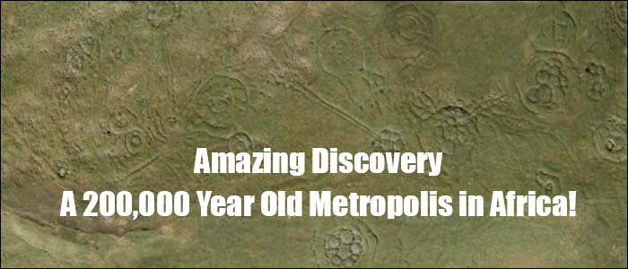
have always been there, people noticed them before, but nobody could remember who made them or why. Until recently, nobody knew how many there were, are now everywhere, not thousands, hundreds of thousands of them!, And the story they tell is the most important story of humanity, but one that might not be willing to listen .
Something surprising has been discovered in an area of \u200b\u200bsouthern Africa, about 150 miles inland, west of the port of Maputo. These are the remains of a large metropolis that measured on conservative estimates, about 1500 square kilometers. It is part of an even larger community of nearly 10,000 square miles and seems to have been built .. Are you ready? 160,000 to 200,000 years BC!
The image to the top of the page is a closer view of a few hundred meters of the landscape taken with google-earth. The region is remote and "circles" are often faced with local farmers who were supposed to made by some indigenous peoples in the past, but strangely, no one bothered to ask about who could have done or how old they are.
This changed when the researcher and author Michael Tellinger was associated with Johan Heine, a local firefighter and pilot had been flying over the region for years looking at the ruins. Heine had the unique advantage of seeing the number and scope of the foundation stone of rare and knew that their importance is not appreciated.
"When Johan introduced me to the ancient stone ruins of southern Africa I had no idea of \u200b\u200bthe incredible discoveries that were made in one year to two, photographs, artifacts and evidence that have accumulated, without doubt, a lost and never seen before, civilization is above all others, no by a few hundred years or a few thousand years ... but of many thousands of years and these findings are so striking that it is easily digested by the tide of history, the fraternity as we have experienced, will require a complete change paradigm in how we view our history - ". Tellinger
Where found
The area is important for the surprising amount of gold deposits. "The thousands of old gold mines discovered in the last 500 years, points to a lost civilization that lived and dug for gold in this part of the world for thousands of years" says Tellinger. "And if this is really the cradle of humanity, we may be looking at the activities of the oldest civilization on Earth. "
To see the number and extent of these ruins, I suggest you use google-earth and begin with the following coordinates:
Then do a search at low altitude in inside the area formed by the rectangle. Simply amazing!
What won gold the dense population that once lived here? The site is about 150 km of an excellent harbor where maritime trade may have helped sustain a large population, but remember we are talking about almost 200,000 years.
individual ruins, especially the most stone circles have been buried in the sand and can only be observed by satellite or aircraft. Some have been exposed by erosion by melting sand, revealing the walls and foundations.
"I look like a type of mind quite open, but I have to admit that I took over a year to assimilate and to realize that we were actually dealing with the oldest structures ever built by man on Earth.
The main reason for this is that we have been taught that nothing of importance has come from South Africa. That powerful civilizations emerged in Sumer and Egypt and elsewhere. We are told that until the liquidation of the Bantu from the north, which was to have begun sometime in the 12 century AD, part of the world was full of hunters and gatherers and so-called Bushmen, who made significant contributions of technology or civilization "-. Tellinger
When explorers first encountered the ruins, which were supposed to be won corals by nomadic tribes such as the Bantu, as it moved south and settled the land of throughout the 13 th century. There was no previous record history of any civilization capable of building over a densely populated community. Little effort was made to investigate the site because the scope of the ruins are not fully known.
the past 20 years, people like Cyril Hromnik, Richard Wade, Johan Heine and others have found that these stone structures are not they seem, in fact, they now believe that the remains of ancient temples and astronomical observatories of lost ancient civilizations date back thousands of years.
These circular ruins extends over a large area, can only be truly appreciated from the air or through modern satellite images. Many of them are almost completely eroded or have been covered by earth movement in agriculture and climate. Some have survived long enough to reveal its size with some original walls standing almost 5 feet tall and four feet wide in some places.
On the whole city, it is obvious that this was a planned community developed by a highly evolved civilization. The number of old gold mines suggests the reason for the community for this location. Found ways, some extending hundreds of miles that connects the community and agriculture in terraces, very similar to those found in the Inca sites in Peru.
But one question begs an answer - how could this be done by humans 200,000 years ago?
This is what you see in google-earth to 25 37'40 .90 "S / 30 17'57 .41 E [A] We are watching the scene from an altitude of 357 meters.
This is not a location "special", just choose randomly, within the area described above. Shows artifacts that are everywhere and we encourage you to search the area with the Internet technology.
circular stone structures are evident from this view, although not visible from the ground. Note that there are many ways very long [B] connecting with groups of circular structures and away by these "paths" that travel for many miles.
The fact that we can see these structures is mainly due to natural erosion, has blown dirt and debris that has been uncovered for thousands of years. Once exposed to the wind, the rocks were covered puedn appear deceptively clean and new.
If you look closely at what first appears to be empty land [C] , you will notice many circles weak, indicating that more homes to hide beneath the surface. In fact, the whole area is full of these structures and connecting roads.
How was dating Site? Once the ruins were examined, the researchers were eager to replace the lost civilization in a historical perspective. The rocks were covered with a patina that seemed very old, but there was sufficient evidence for carbon-14 dating, was then a chance discovery revealed the age of the site, and sent a shiver down the spine of archaeologists and historians!
Finding the remains of a great community, with as many as 200,000 people living and working together was a great discovery in itself. The heavy patina on rock walls suggested that the structures were very old, but the science of the patina that only data is being developed and is still controversial. Carbon-14 dating of burnt wood such things as introducing the possibility that the samples could be of recent grass fires are common in the area.
The breakthrough came unexpectedly as described Tellinger:
"Johan Heine Calendar Adam discovered in 2003 almost by accident. It was on the path to find one driver who crashed his plane on the edge of the cliff. Next to the scene noticed a strange Johan arrangement of large stones protruding from the ground. While rescuing the injured driver about 20 meters down the side of the cliff, Johan went to the monoliths and immediately realized that they were aligned with the cardinal points of the earth - north, south, east and west. there are at least three monoliths aligned to the sunrise, but on the west side of the monoliths had a mysterious hole aligned on the floor, something was missing. "
After weeks and months of measurements and observations, Johan concluded that it was perfectly aligned with the rise and fall of the sun. He determined the solstices and equinoxes, but the mysterious hole in the ground was still a great puzzle. One day, looking at the hole, the local expert on horses and trails, Christo, came riding, Johan quickly told that there was a strange shape on the ground like a stone removal from the place some time ago. Apparently, he was somewhere near the entrance to the nature reserve.
After an extensive search, Johan are the anthropomorphic (humanoid) stone. Was intact and proudly placed a plaque attached to it. Had been used by the Blue Swallow foundation to commemorate the opening of the Blue Swallow Reserve 1994. The irony is that it was removed from the most important ancient site found so far and mysteriously returned to the reserve for slightly different reasons.
The exact location of the calendar appears in www.makomati.com. Early estimates of the age of the calendar made based on the increase of Orion, a constellation known for its three bright stars forming the belt of the legendary hunter.
Earth wobbles on its axis so the stars and constellations change their angle of presentation in the night sky on a cyclical basis. This rotation is called Cycling precession approximately every 26,000 years. In determining when the three stars of Orion's belt is placed flat (horizontal) on the horizon, we can estimate the time that the three stones on the calendar are visible in the alignment of these stars.
The first estimate was at least 25,000 years ago. But new and more precise measurements of age continued to rise. The following calculation was presented by a master archaeoastronomer who wishes to remain anonymous for fear of ridicule by the academic fraternity. Its calculation is based also on the increase and suggests Orion age of at least 75,000 years. The most recent and most accurate measurement was made in June 2009, suggests an age of at least 160,000 years, based on the increase of Orion - flat on the horizon, as well as the erosion of the stones found dolerite on the site.
Some parts of the marker stones were broken and sitting on the ground, exposed to natural degradation. When the pieces put back about 3 cm stone had been worn. These calculations helped evaluate the age of the site to calculate the rate of erosion of the dolerite.
Who made the metropolis? Why? Why?
seems that humans have always valued gold. Even mentioned in the Bible, which describes the Garden of Eden's rivers:
seems that humans have always valued gold. It is Mentioned in the Bible events, Describing the Garden of Eden's rivers: even be mentioned in the Bible, which describes the Garden of Eden's rivers:
Genesis 2:11 - The name of the first river Pison, flowing around the whole land of Havilah, where there is gold.
South Africa is known as the country's largest gold producer in the world. The area's largest gold producer in the world is the Witwatersrand, in the same region where the ancient metropolis. In fact, near Johannesburg, one of the best known cities of South Africa, also known as "Egoli", meaning the city of gold.
GOLD MINES - How long?
Is there evidence that mining took place in southern Africa during the Stone Age? Archaeological studies indicate that in fact happened.
Realizing that the sites of old abandoned gold mines may indicate where to find leading mining company in South Africa, the Anglo-American Corporation, in the 1970 dedicated to the archaeologists to look like old mines. Published reports (Optima) detail the discovery in Swaziland and elsewhere in southern Africa in areas with extensive mining shafts at depths of fifty feet, stone objects and charcoal remains established dates of 35,000, 46,000 and 60,000 BC for these sites. Archaeologists and anthropologists who joined in the dating of the finds believe that the extraction technology used in South Africa "during much of the post to 100,000 BC "
In September 1988, an international team of physicists came to South Africa to verify the age of human habitats in Swaziland and Zululand. The most modern techniques indicated an age of between 80,000 and 115,000 years.
As for the gold mines Monotapa oldest in southern Zimbabwe, Zulu legends claim they were worked by the "slaves of the flesh and blood produced artificially created by the first people, the legends tell Zulu of these slaves, "went to battle with the ape-man," when "the star of the war appeared in the sky."
is very likely that the former colonial power was established there because of its proximity to the largest source of gold in the world. But why ancient people worked so hard to extract gold? It is too soft for making tools, it is not really useful for anything, except for trim and physical beauty is on par with other metals such as copper or silver. Exactly why gold was so important to the early Homo sapiens?
To explore the response we have to look at the historical period in question - 160,000 to 200,000 years a. C. - And learn what was happening on planet Earth.
What were the human beings as 160,000 years ago? Modern humans, Homo sapiens, our ancestry can be traced through time to a point in which our species evolved from other, more primitive hominids. Scientists do not understand why this new type of human suddenly appeared, or how the change occurred, but genes can trace back to a single woman who is known as mitochondrial Eve. "
Mitochondrial Eve (mt-MRCA) is the name given by researchers to the woman who is defined as most recent common ancestor through the maternal line (MRCA) for all humans living today. It is transmitted from mother to child, all the mitochondrial DNA (mtDNA) in all living stems from this individual female. Mitochondrial Eve is the female counterpart of Y-chromosome Adam, the most recent common ancestor in the paternal line, even though they lived at different times.
Mitochondrial Eve is believed to have lived between 150,000 and 250,000 years BP, probably in East Africa in the region of Tanzania and areas south and west immediately. Scientists speculate that living in a population of between 4000 to 5000 perhaps women able to produce offspring at a given time. If other women had babies with evolutionary changes in DNA have no record of their survival. It seems that we are all descendants of this woman a human being. mitochondrial Eve would have been more or less contemporary with humans whose fossils have been found in Ethiopia, near the Omo River and Hertha. Mitochondrial Eve lived long before the migration from Africa that could have happened for some 60,000 to 95,000 years.
Africa region where the higher level of mitochondrial diversity (green) and anthropologists postulated region old division in most human populations began to occur (brown). The ancient metropolis located in the latter (Brown), a region that also corresponds to the estimated age when genetic changes occur suddenly.
Could this be a coincidence?
ancient Sumer History describes the ancient metropolis and its inhabitants!
I'll be honest with you. The next part of the story is hard to write, is so shocking that the average person will not believe it. If you're like me, want to do the research yourself, then take a little time for facts to settle in his mind. Often makes us believe that the Egyptians, the Pharaohs, pyramids, are where our story begins known. Oldest dynasties dating back some 3200 years BP. That was long ago. But the Sumerian civilization in what is now Iraq, is much older, what is more, we have translated many of the tablets of history, written in cuneiform and earlier so we know a lot about its history and legends.
The stamp image [above] represents the legend of the "great flood", which consumes humanity. Many legends Sumerian are remarkably similar to Genesis. Like Genesis, the Sumerian legend, Atrahasis, tells the story of the creation of modern humans - not by a loving God - but by beings from another planet who needed to "slave labor" to help extract gold shipment extra-planetary!
warned that it is hard to believe, but please read on.
The origin of modern humans
This history, Atrahasis comes from an early Babylonian version from around 1700 BC, but it certainly goes back to Sumerian times. Combine family reasons Sumerian creation of humanity and the flooding back - like Genesis.
The story begins with the "gods" - the beings from a planet called Nibiru - trenching and mining of gold as part of a team of explorers. Modern humans (Homo sapiens) do not exist, only the earliest humans lived on Earth. There were two groups of "gods", the working class and the ruling class (ie official). The gods of the workers had built the infrastructure and working in gold mines and, after thousands years, the work was apparently too much for them.
The gods had to dig channels lifelines of the land, then pulled the Euphrates. - (Dalley 9, Atrahasis)
After 3600 years of this work, the gods finally begin to complain, they decide to strike, burning their tools and around the main god Enlil tells the crowd angry, afraid Enlil (His face is described as "sallow as tamarisk.") The vizier Nusku Enlil advised to summon the great gods, especially Anu (sky god) and Enki (the god intelligent freshwater). Anu Enlil advised to determine who is the ringleader of the rebellion, sent Nusku to ask the multitude of gods who is their leader. The crowd responds: "Each of us has declared war gods" (Dalley 12, Atrahasis).
Since the gods of the upper class now see that the work of the gods of the lower class "was too hard," he decided to sacrifice one of the rebels for the good of all. Will be a god, kill it, and that mankind by mixing meat and blood of the god with clay:
Belit-ili the womb goddess is present, let the belly of the goddess create offspring, And the man carrying the load of the gods! (Dalley 14-15, Atrahasis)
Enki instructs After purification rituals for the first, seventh and fifteenth each month, the slaughter-e Geshtu gods, a god who had intelligence "(his name means" ear "or" wisdom ") and humanity in the form of blood and some clay. After birth the goddess of the clay mixture, all troops of the gods, then Enki and the goddess of the clay matrix takes in "the room of fate," where the belly of the goddesses were assembled.
He [Enki] trod the clay in her presence; She kept reciting an incantation, For Enki, staying in his presence, made him recite. When he had finished his spell, He pinched fourteen pieces of clay, And with seven pieces of the right, left Seven. Among them, she left a mud brick. (Dalley 16, Atrahasis)
The creation of man seems to be described as a type of cloning and what we consider in vitro fertilization.
The result was a hybrid or "human evolution" with a higher intelligence that would serve as the gods of physical labor and also address the needs of all the gods.
We are told, in others, the expedition reached the gold and that large amounts were removed and transported off the planet. The community in South Africa called "Abzu" and was the primary site of the mining operation.
As these events appear to coincide with the dates "mitochondrial Eve" (ie, between 150,000 and 250,000 BP) and appear to be located in the mining region of the world's richest gold (Abzu), some researchers think Sumerian legend that may, in fact, is based on historical facts.
According to the texts themselves, once the issue of mining ended it was decided that the human population should be allowed to perish in a deluge that was predicted by the "gods" astronomers. Apparently, the cyclic passage of the gods home planet, Nibiru, which would bring it close enough to the Earth's orbit that gravity would cause the oceans, increasing floods and earth, ending the hybrid species - homo sapiens.
According to the story, one of the "gods" I had sympathy for a particular human being, Zuisudra, and warned him to build a boat to ride out the flood. This eventually became the basis of the story of Noah in the Book of Genesis.
Is this really happening? The only other explanation is conceivable that the Sumerian legends, recognizing life on other planets and human cloning, were extraordinary in science fiction. This in itself is amazing. But now we have evidence that the mining town, Abzu, is real and it existed at the same time that the sudden evolution of hominids to homo sapiens.